Road signs inventory and analysis
Accurately map and inventory even custom signs on your roads. Spot missing signs and reflectivity loss with every survey run. Keep your data fully secure, anonymized, and stored on-premises while exporting hassle-free to GIS shapefiles, Excel, and CSV formats.
First step: the inventory
A reliable defect analysis starts with a flawless inventory. TraCK leverages advanced edge AI to automatically detect, classify, and map every traffic sign in your network using standard vehicle cameras. Thanks to high-precision GPS and frame-by-frame tracking, the system captures the exact position of each panel—building a dynamic, always-accurate digital database that makes it effortless to catalog existing assets and instantly flag missing ones. Need custom sign recognition? Simply share your digital sign catalog with us, and we can easily train TraCK to identify your specific local signs.
And then, map the defects
Colour fading analysis
Automatically assess sign legibility and weathering long before it becomes a safety hazard. Once TraCK identifies and classifies a road sign, it goes far beyond simple apparent color loss. By applying intelligent image transformations and color normalization the system eliminates light, shadow, and weather distortions to isolate true chromatic degradation and retention. This delivers far more accurate results, automatically categorizing panel conditions into Good, Suspect, or Bad so operators get immediate, clear insights without manual visual checks.
Retroreflectivity analysis

Evaluate nighttime visibility without complex manual measurements. Operating during night surveys with IR-equipped vehicle cameras, TraCK analyzes the light reflected by each portion of a road sign across multiple consecutive frames, to return a robust reflectivity estimation. Rather than outputting raw, dense reflectivity values, the system provides an immediate, automated condition classification—allowing operators to skip compliant signs and focus their time exclusively on the ones that actually require in-depth inspection.
Physical defects
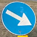
Scratches
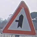
Bent panels
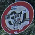
Stickers
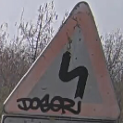
Graffiti
Your data, your platform
Privacy and data ownership are non-negotiable. On your roads, your data stays yours: TraCK never uploads images to the cloud, natively blurs faces and license plates in real time, and processes frames directly on your vehicle's onboard PC. Limited onboard computing power? Easily offload survey imagery to run TraCK analytics on your local server instead. Whichever workflow you choose, you retain total data freedom with seamless exports to your existing platform.

GIS shapefile
CSV